
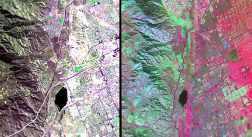
The HyspIRI airborne campaign overflew California’s San Andreas Fault on March 29, 2013. The three-color (red, green, blue) composite image of the fault (left), composed from AVIRIS data, is similar to what a snapshot from a consumer camera would show. The entirety of data from AVIRIS, however, spans the visible to the short-wavelength infrared part of the spectrum. Temperature information (right) was collected simultaneously by the MASTER instrument. Red areas are composed of minerals with high silica, such as urban areas, while darker and cooler areas are composed of water and heavy vegetation. Image credit: NASA/JPL
(Visited 38 times, 1 visits today)