
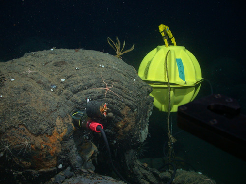
A seismometer inserted into a hole drilled in seafloor lava. Eight of these instruments were installed at an ocean spreading-center volcano 150 miles off Vancouver Island. A data recording device is enclosed in the yellow sphere. In three years of operation the network detected nearly 40,000 small earthquakes, and hundreds of thousands of fin-whale calls. Image credit: John Delaney and Deborah Kelley, UW (taken with remotely operated vehicle Jason)
[#Beginning of Shooting Data Section]
Nikon CoolPix995
2004/08/04 19:31:00
JPEG (8-bit) Fine
Image Size: 2048 x 1536
Color
ConverterLens: None
Focal Length: 8.2mm
Exposure Mode: Manual
Metering Mode: Multi-Pattern
1/30 sec – f/2.6
Exposure Comp.: 0 EV
Sensitivity: ISO 100
White Balance: Auto
AF Mode: AF-S
Tone Comp: Auto
Flash Sync Mode: Front Curtain
Electric Zoom Ratio: 1.00
Saturation comp: 0
Sharpening: Auto
Noise Reduction: OFF
[#End of Shooting Data Section]